Surveying And Mapping
“The most effective way to achieve a robust and globally consistent continental reference system is through the technology of the Global Positioning System (GPS). The explosive growth of GPS applications and the economics of GPS make it the technique of choice for sustainable geodetic operations within Africa.”
Claude Boucher, Former Secretary General, International Association of Geodesy (IAG)
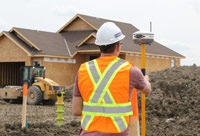
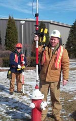
The surveying and mapping community were one of the first to adopt and use GPS because the reliability and accuracy increased their productivity greatly. It has now become a vital and important part of the fields. When used by professionals, GPS provides the highest accuracy (compared to conventional methods), and is much faster; reducing the work, employees, equipment, etc. in the fields.
GPS is very useful to surveying and mapping fields because it accurately maps/models the whole planet (i.e. mountains, rivers, streets, buildings, utility lines, cars, blockages, etc.). These can be displayed on maps, receivers, and in geographic information systems (GIS) that store, manipulate, and display geographically referenced data. Resources and timely decisions are facilitated using GPS and GIS by many organizations including: government, scientific organizations, commercial operations, etc. GPS and GIS is very valuable and beneficial for these organizations requiring accurate location information about its assets.
GPS is not bound by constraints such as line-of-sight visibility between survey stations; meaning they can be placed at great distances from each other (as long as they have good visual of the sky). GPS is also extremely useful in surveying coasts, waterways, lakes, rivers, ponds, etc. This is because there are few land-based reference points, so GPS and SONAR are used together to detect nautical charts which alert mariners and civilians of changing water depths, underwater hazards, etc. These graphs (which are dated) are also useful to bridge builders (for distance above the water), offshore oil rigs (for hydrographic surveys), etc.
On land, mappers and land surveyors can carry GPS systems very easily because of their small sizes. They can be stored in backpacks, mounts, vehicles, etc. for accurate data collection which is also fast. GPS can also be used for motion studies to build better offices, direct flow of pedestrians or animals, analyse paths, etc. Current survey-grade receivers, to achieve the highest level of accuracy, use two GPS radio frequencies: L1 and L2. The problem is that there is no current civilian signal at L2, so these receivers use a military L2 signal using “codeless” techniques. To combat this issue, the GPS modernization program is adding a dedicated civil signal at L2. These allow for centimeter-level surveying results in real-time!

|
|

GPS and Kinematics by Simarjeet Singh Thind is licensed under a Creative Commons Attribution-NonCommercial-ShareAlike 4.0 International License.
Based on a work at http://www.gps.gov/.
