Simple Step-By-Step
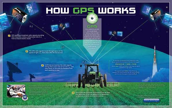
1. The GPS satellites emit and broadcast radio signals which provides their location, precise time (t1), and status from on-board atomic clocks (which are the most accurate types of clocks created).
2. The broadcasted radio signals by the satellites travel through space (vacuum) at the speed of light (c), which is more than 299, 792 km/second.
3. The GPS receiver receives the radio signals, and notes their exact time of arrival (t2). These are used to calculate its distance from each satellite in view. To calculate this distance from a satellite, the GPS device uses kinematic algorithms such as the following formula: distance = rate x time, where rate is (c) and time is how long the signal travelled through space. Also, the signal’s travel time is the difference between the time broadcast by the satellite (t1) and the time the signal is received (t2).
4. The device requires at least four satellites to know its distance. It can use geometry to determine its location on Earth in three dimensions.
Note: The GPS Master Control Station tracks the satellites using a global monitoring system (which keeps the satellites in their precise orbit) and manages their health every day. Antennas on the ground around the world send data updates and operational commands to the 24 satellites. The US Air Force launches new satellites to replace aging ones when needed (these new satellites, which are rarely replaced, offer upgraded accuracy and reliability.

GPS and Kinematics by Simarjeet Singh Thind is licensed under a Creative Commons Attribution-NonCommercial-ShareAlike 4.0 International License.
Based on a work at http://www.gps.gov/.
