Environment
“Until the advent of GPS tracking, it was practically impossible to record elephant movements with sufficient temporal resolution to give a full picture of movement patterns. The presence of elephants in Kenya is a key indicator of the health of the environment.”
Honorable Dr. Newton Kulundu, Minister for Environment, Natural Resources, and Wildlife, Kenya
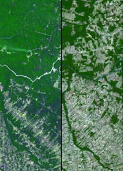
Many environmental concerns can be addressed using GPS data and information which has been collected by GIS packages. This gives a comprehensive analysis for environmental concerns in many areas of the world (such as the Amazon deforestation). Using this data collected by the GPS and GIS, environmental patterns and trends can be analysed, and thematic maps can be created easily. The good thing about using GPS for environmental reasons is that the data can be analysed with the primary need for field data transcription into digitized form! Also, because of the more frequent forest fires because of global warming, and oil spills due to more nations and companies taking part in oil exploration/extraction, GPS can allow for more accurate/efficient tracking of these environmental disasters. An example of this is how GPS helped cleanup crews respond to the oil spill in the Gulf of Mexico in 2010. GPS can also assist with water and land data collection for crustal and seismic monitoring which is very precise positional data to be used by scientists. Lastly, GPS receivers can be used to track and monitor endangered species and their patterns for their preservation. This can also create detailed maps for the species!

GPS and Kinematics by Simarjeet Singh Thind is licensed under a Creative Commons Attribution-NonCommercial-ShareAlike 4.0 International License.
Based on a work at http://www.gps.gov/.
