How Does GPS Work?
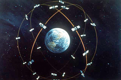
The 24 satellites circle the earth twice a day in a very precise orbit and transmit signals of information to earth the form of radio waves. The receivers on earth take this information from the satellites and use triangulation and trigonometry to calculate the user’s exact location in three dimensions. It compares the time a signal was transmitted by the satellite with the time it was received; this time difference tells the gps receiver how far away the satellite is using kinematic equations. This process repeated by more satellites, the distance measurements can be used to determine the user’s position and display it on the unit’s electronic map. This information and kinematic equations used can also determine the estimated time of arrival (ETA), speed, distance, etc. This information is very useful for mapping, surveying, and for civilians using it during driving for directions (i.e. Google Maps).

GPS and Kinematics by Simarjeet Singh Thind is licensed under a Creative Commons Attribution-NonCommercial-ShareAlike 4.0 International License.
Based on a work at http://www.gps.gov/.
